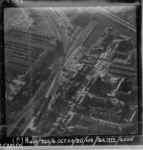
The First Canadian Army Air Photo collection was brought to the Laurier Center for Military Strategic and Disarmament Studies (LCMSDS) in 1985. Originally being used for the Air Photo Interpretation Section of the First Canadian Army during the Normandy Campaign and Northwest Europe in 1944-45, it was transported after the war to the air photo interpretation school at Rivers in Manitoba. In 1971 the base closed and the collection was sent to the Canadian War Museum. Due to insufficient storage space, the collection found its way to Wilfrid Laurier University, where the collection encompasses over 130,000 photographs in its entirety.
Thanks to private donors and a largely volunteer workforce, in 2011 LCMSDS was able to start the process of cataloguing and digitalizing the photographs. After thousands of hours of work, the project was completed in August 2013 and now may be accessed by the public either online or physically through the center.
Thanks to the efforts of those involved, the Laurier Military History Archive has one of the largest collections of aerial photos in the country and has been used in a variety of different ways. For example, during one of my first weeks working for the LCMSDS, I was charged with scanning and sending air photos to a bomb disposal group in the Netherlands. Frequent requests such as this are made monthly and the air photos help companies such as these to see where ordinance was dropped, and where they may not have exploded.
Requests have also been made for aerial photos that have not already been identified. These queries usually use recent Google images of an area of interest. The Center’s job is to find an air photo that matched the respective area. It was described to me as being a detective process. Sometimes areas can be matched quite easily due to similar ground features, other times it is requires long hours of comparison. Yet, it is all very interesting to be researching these photos and trying to match to one of the 130,000 photographs we have in our collection.
The Aerial Photos can be found at the LMH website. The Browse Our Collection tab allows you to search by country, and then by province for specific air photos. The corresponding box and photo numbers match up to the individual photo in the archives and can be accessed through the front desk of the center.
—
Bibliography
Newman, Kevin. Declassified WWII aerial recon photos made public on the web today: [GLOBAL NATIONAL Edition]. Toronto: Infomart, 2004.


Good morning Rebekah, and everyone involved in the aerial photo digitization project.
Have you considered crowd-souring information for the photos? Recently I was looking for aerial photos which matched the action by the Essex Scottish at le Noyers on 29 July 1944 described in their war diary (also avalable through LCMSDS … yay!). After a fair bit of fumbling around and looking at maybe a couple of thousand photos i found several photos from the 6th and 8th August taken from 29,000′, which was wonderful. However, I suspect there are several hidden away in the archive taken in late July from much lower altitudes, which would be a lot more useful in terms of detail.
In the course of reviewing all those photos I started to get a sense, and ‘memory’ of what I was looking at. I could readily recognise, for example, Beauvoir Farm, or the rail crossing just south-west of Tilly-la-Campagne of the road between Caen and Falaise. Also, after a bit of practice I got a sense of the ‘run’ of strips taken in a single pass, and could sort-of locate photos (as in, ‘oh, that’s over the Orne somewhere near Maltot’ or ‘ah, that area of orchards is over towards Mezidon’).
I really wanted to be able to annotate the photos, and possibly geo-tag them, both for my own convienience, and to help out the next person looking for a particular location. It’d be great if you were able to add a ‘column’ in the finding aid which anyone could edit to enter, say, the names of villages shown in the image, or a G-maps link to the locations shown.
Hopefully you’re able to give this some consideration, and thanks for your fabulous efforts in making this available.
Best Regards
Jon Sowden
Wellington
NZ
Great work! congratulations! I have waited for this for a long time!
Fully agree with Jon Sowden.
Ad an additional collum to fill in comments and/or locations. Including a search option.
I do the same sometimes look at many pictures, find some known areas but don’t send it to the LMH Archive.
I will fill in the extra collum if available.
Bernhard